Exploring Texas on foot? It’s honestly one of the best ways to soak in the state’s wild beauty. From canyons painted in desert reds to thick forests and stony hilltops, the hiking trails here are as varied as the weather.
I’ve rounded up the top 10 Texas hiking trails with the most jaw-dropping views, so you can get out there and see the best of what we’ve got.
These trails made my list because they deliver on scenery and memorable overlooks. Looking for wide-open vistas, shady woods, or cliffs that make your stomach drop? You’ll find a trail here that hits the mark.
Doesn’t matter if you’ve logged miles in hiking boots or want a new weekend adventure—these are worth checking out.
- Overview of Scenic Hiking Trails in Texas
- Top 10 Texas Trails for Spectacular Views
- Big Bend National Park: Iconic Trails and Vistas
- Guadalupe Mountains National Park: Peaks and Panoramas
- Hill Country Gems: Waterfalls, Mountains, and Forests
- Canyon Adventures: Palo Duro and Caprock Canyons
- East Texas Forests and Long-Distance Trails
- Additional Scenic Trails and Less-Explored Destinations
Overview of Scenic Hiking Trails in Texas
Texas trails wind through canyons, skirt rivers, cut across forests, and circle lakes. Every time I hike, I run into plants, critters, and landforms I didn’t expect.
Diversity of Texas Landscapes
When I set out on Texas trails, I never know what I’ll get—desert, mountains, thick woods, or riverbanks. Guadalupe Mountains? Rocky peaks and cactus. Caddo Lake State Park? Shady woods and still water.
The Hill Country rolls with oaks and juniper, while Palo Duro Canyon drops off into bright red cliffs and wild rock layers. East Texas is all about pine forests and lakes, but head west and it’s dry, open, and big-sky country.
Sometimes I spot deer; sometimes it’s just birds or the occasional armadillo. The landscape always keeps me guessing. That’s what makes hiking here so good—it never gets old.
What Makes a Trail Scenic
To me, a scenic trail needs those moments where you just have to stop and take in the view. Perhaps it’s a waterfall, a peculiar rock formation, or a vista that stretches out forever.
Take the South Rim Trail in Big Bend—it’s all desert and mountains as far as you can see. Gorman Falls Trail? You round a bend and suddenly there’s a tall waterfall hidden by green.
Wildlife helps too. I love catching sight of a fox or hearing birds overhead. Clear rivers like those at Pedernales Falls or the red cliffs at Palo Duro stick in my mind long after. And when Texas wildflowers explode in spring, every trail feels like a new world.
Best Seasons for Hiking in Texas
I always check the seasons before making plans. Spring and fall are my favorites—the weather’s just right, and everything looks alive.
In the Hill Country, October and November transform the trees into a vibrant display of red and gold, especially at Lost Maples State Natural Area. Summer? It gets brutal. I try to beat the sun by hiking early, picking shady routes, or heading up to the Davis Mountains where it’s cooler.
Texas winters are relatively mild, so I sometimes go hiking when other states are buried under snow. But I keep an eye on rain and river levels—flash floods can sneak up on you. Timing can make or break a hike here.
Top 10 Texas Trails for Spectacular Views
I chose these trails because they’re rich in scenery and take you through some of the state’s most interesting spots. There are easy and challenging hikes, deserts, canyons, waterfalls, and forested hills—something for every kind of hiker.
Selection Criteria for Top Trails
When I narrowed down this list, I looked for trails with unforgettable views along the way. Guadalupe Peak Trail is cut because it climbs to the highest spot in Texas, and the summit gives you the whole world at your feet.
I also checked out what other hikers had to say, looked for unique features like rock formations or river crossings, and paid attention to distance and elevation. Some trails, like Lost Mine, are a real workout; others, like White Rock Lake, are a breezy stroll.
Easy access, safety, clear signs, and a chance to spot wildlife or rare plants all mattered. I wanted every hike to be beautiful and doable for most folks.
Map of Must-See Trails
Here’s a quick look at where these top scenic trails are, what they’re known for, how far you’ll walk, and how much you’ll climb:
| Trail Name | Park/Area | Distance (mi) | Elevation Gain (ft) | Notable Views |
|---|---|---|---|---|
| Guadalupe Peak Trail | Guadalupe Mountains NP | 8.5 | 2,950 | Highest point in Texas |
| Lost Mine Trail | Big Bend NP | 4.8 | 1,100 | Mountain and desert panoramas |
| The Window Trail | Big Bend NP | 5.5 | 948 | Dramatic canyon vistas |
| Lighthouse Trail | Palo Duro Canyon SP | 5.7 | 500 | Iconic red rock formations |
| Santa Elena Canyon Trail | Big Bend NP | 1.7 | 80 | Towering limestone canyon walls |
| White Rock Lake Trail | Dallas | 9.3 | 137 | Lakeside city skyline, birds |
| Twin Falls/Sculpture Falls | Austin (Barton Creek) | 3.2 | 200 | Waterfalls, swimming holes |
| Penitentiary Hollow | Lake Mineral Wells SP | 2.5 | 200 | Canyon floor, giant elm trees |
| Llano Grande | Rio Grande Valley | Varies | Minimal | Birdwatching, river vistas |
| Crockett Gardens Falls | Georgetown | 2.5 | 164 | Waterfall, creekside scenery |
Tips for Planning Your Hike
I never leave home without checking the weather—Texas heat and storms are no joke. Water is non-negotiable. Some of these trails get downright dry and scorching.
I opt for light clothing, a hat, and sunscreen when the trail is exposed to the sun. If I’m on rocky ground, I grab sturdy shoes with a good grip; for flat, easy trails, sneakers sometimes work.
Many parks charge entrance fees or require parking permits. I check the park’s website before heading out, just in case.
Starting early is my secret to avoiding crowds and the hottest part of the day, especially on popular routes. I like to have a downloaded map (AllTrails is handy) or a paper backup, since cell service disappears in the wildest places.
I tell someone my route and when I plan to be back. If I’m solo, I stick to busier, well-marked trails. Safety first, always.
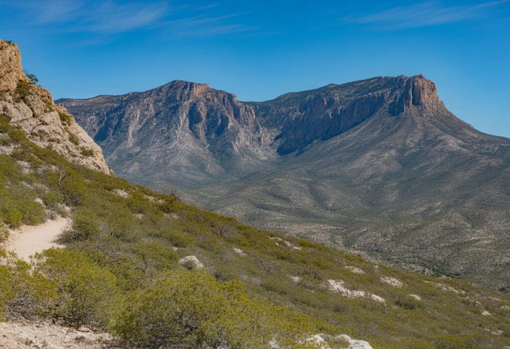
Big Bend National Park: Iconic Trails and Vistas
Big Bend National Park nails it for hikers—it’s got the Chihuahuan Desert, the Rio Grande winding through, and the rugged Chisos Mountains. If I’m after the best Texas views, I head here first.
South Rim Trail Overview
The South Rim Trail is my go-to for those massive, sweeping desert views. It’s about 12.6 miles round trip and climbs roughly 2,800 feet, so it’s not a casual stroll.
I start in the Chisos Basin, weaving through oaks and pines. Eventually, the trees thin out and suddenly, the rim drops away and you can see for miles—deep canyons, jagged peaks, endless desert.
I often spot deer or hear birds as I go. This trail is challenging, so I pack plenty of water and snacks and make sure I’m up for a workout.
The trail is well-marked, and you can loop it in a few different ways. If I feel ambitious, I tack on a side trip to Emory Peak. It’s smart to check trail conditions, especially in summer when the heat gets real.
Santa Elena Canyon Trail Highlights
Santa Elena Canyon Trail offers an entirely different vibe compared to the mountain hikes. It’s short—just 1.7 miles round trip—but wow, the scenery is wild.
You walk beside the Rio Grande, with limestone walls that shoot up 1,500 feet overhead. The trail kicks off at the end of Ross Maxwell Scenic Drive.
A quick climb puts you at a lookout, then the path drops down to the riverbank. The sound of the water and the cool shade make it a favorite of mine, especially on hot days.
I spot birds, maybe some fish, or Jake in the echo of the canyon. It’s easily accessible and great for families. After rain, though, it gets muddy—worth checking before you go.
Emory Peak Experience
Climbing to Emory Peak is always a thrill. It’s the highest point in Big Bend at 7,825 feet, so the views are just unbeatable.
The hike is approximately 10.4 miles round trip from Chisos Basin, with an elevation gain of around 2,440 feet. I wind through pine trees, then up rocky switchbacks.
The final stretch? Short but steep rock scramble. At the top, I get a 360-degree view—Chisos Mountains, the South Rim, the desert, even Terlingua Creek, and hints of the Rio Grande.
Tips for Emory Peak:
- Bring at least 3 liters of water
- Start early to beat the heat
- Expect wind and sun up top
It’s not for the faint of heart or those who hate heights, but the payoff? Worth it.
Guadalupe Mountains National Park: Peaks and Panoramas
Guadalupe Mountains National Park is all about sharp ridges, endless desert views, and wild canyons. It’s where you’ll find the highest point in Texas, plus some of the state’s most dramatic hikes.
Guadalupe Peak Trail: The Highest Point in Texas
If I’m craving a challenge (and views that go on forever), I pick the Guadalupe Peak Trail. At 8,751 feet, it’s Texas’s rooftop.
The trail runs approximately 8.4 miles round trip, featuring a challenging climb of over 3,000 feet in elevation. I hike through pine and fir forests that feel nothing like the desert below.
The air cools as I climb, and the views continue to expand. At the summit, a silver pyramid marks the highest spot, great for a victory photo.
Wind and weather can change fast up here, so I come prepared. It’s a challenging hike, but the panorama from the top makes every step worthwhile.
Key Details:
- Distance: 8.4 miles round trip
- Elevation Gain: 3,000+ feet
- Best For: Experienced hikers chasing big views
Devil’s Hall Adventure
Devil’s Hall Trail stands out as one of my favorite moderate hikes in Guadalupe Mountains National Park. The 4.2-mile round trip starts easily, then turns into a scramble over rocky washes and natural stone steps.
It leads through a canyon with tall walls and some wild rock formations. The “Devil’s Staircase,” a set of stone steps shaped by water, always grabs my attention.
At the end, the dramatic “hall” forms a corridor between close canyon walls—a perfect spot for photos and a bit of shade. The trail doesn’t have much elevation gain compared to Guadalupe Peak, so it’s a good pick for folks who want a scenic adventure without a brutal climb.
Desert plants and hidden pools emerge along the way, adding considerable variety to the hike.
At a Glance:
- Distance: 4.2 miles round trip
- Elevation Gain: About 600 feet
- Features: Stone steps, slot canyon, varied terrain
Other Scenic Trails
Guadalupe Mountains National Park offers numerous trails with stunning views and a diverse mix of scenery. The Smith Spring Trail, a 2.3-mile loop, is a pretty easy walk and passes two natural springs surrounded by shade trees and desert wildlife.
I’ve spotted deer and birds along this path more than once. The McKittrick Canyon Trail is all about those fall colors.
The hike to Pratt Cabin and the Grotto covers approximately 7 miles round-trip. If you time it right—late October—the leaf colors pop.
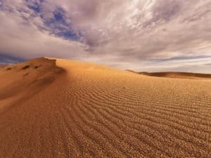
For something completely different, the Salt Basin Dunes Trail lets you wander among white dunes. It’s only about 3 miles round trip, mostly flat, and the Guadalupe Ridge rises in the distance.
Quick Comparison Table
| Trail Name | Length (mi) | Difficulty | Key Features |
|---|---|---|---|
| Smith Spring | 2.3 | Easy | Springs, wildlife, shade |
| McKittrick Canyon | 7 | Moderate | Fall colors, historic cabin |
| Salt Basin Dunes | 3 | Easy | Sand dunes, desert vistas |
Hill Country Gems: Waterfalls, Mountains, and Forests
In the Texas Hill Country, trails wind past tall waterfalls, rocky climbs, and thick forests. Each area feels a little different, but the natural beauty is undeniable.
From limestone bluffs to lush valleys, these hikes show off some of the best views you’ll find in Texas.
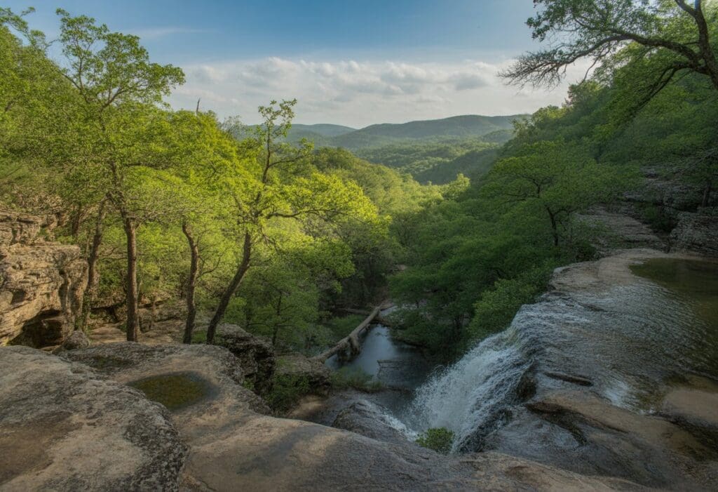
Gorman Falls Trail in Colorado Bend State Park
On the Gorman Falls Trail, I follow rocky paths through the woods until I hear the rush of water. Soon, I reach the dramatic 60-foot Gorman Falls cascading down limestone cliffs draped with moss.
The trail is approximately 3 miles round trip and is rated as moderate. It’s manageable for most folks who don’t mind uneven ground.
Colorado Bend State Park feels remote, and shady spots are rare, so I always haul plenty of water. At the base of the falls, water tumbles into a clear pool, surrounded by ferns and wildflowers, if you catch it in spring.
Taking a break in the cool mist at the bottom is one of those little moments I look forward to.
- Trail Length: ~3 miles round trip
- Difficulty: Moderate
- Best for: Waterfall views, spring wildflowers, unique limestone scenery
Mount Ol’ Baldy Trail at Garner State Park
Mount Ol’ Baldy Trail wastes no time—it’s under a mile, but it’s steep and rocky from the get-go. I huff my way up, but at the summit, the views of the Frio River winding below and green hills rolling out for miles make it all worthwhile.
Garner State Park gets busy for river swimming in summer, but the view from Ol’ Baldy is my favorite part. The hike’s especially popular around sunset when the light spills over the valley.
I always tell people to wear sturdy shoes—loose rocks make the climb and descent a bit tricky.
- Trail Length: 0.8 miles
- Difficulty: Strenuous, steep and rocky
- Best for: Stunning overlooks, Frio River, quick but challenging hike
Lost Maples State Natural Area and East Trail
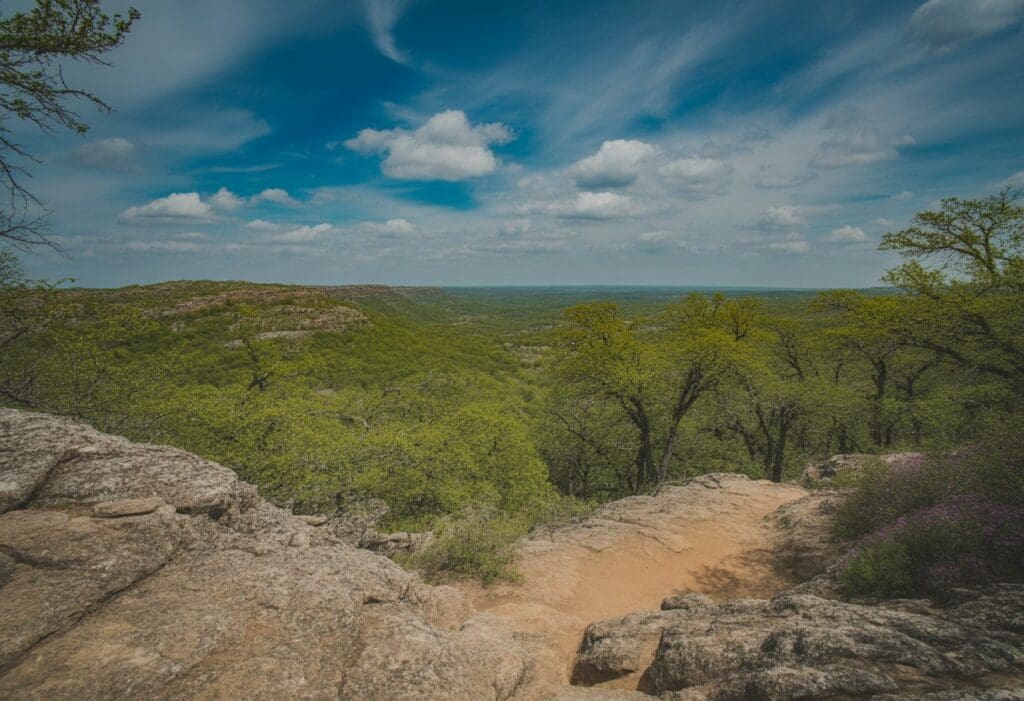
Lost Maples State Natural Area’s East Trail takes me through dense maple forests, rocky canyons, and up high ridges with big scenic overlooks. The trail stretches about 4.4 miles and includes some challenging climbs, but the expansive views of the Sabinal River Valley and those maple leaves in the fall are worth every step.
I love ducking under old trees, spotting wildlife, and stopping at the lookout points. The preserve tends to be quieter than some parks, so I get a bit more peace while hiking.
The East Trail is my go-to for autumn colors or just soaking up the quiet beauty of the Hill Country.
- Trail Length: 4.4 miles
- Difficulty: Moderate to strenuous
- Best for: Fall foliage, bird watching, peaceful hiking through forests and canyons
Canyon Adventures: Palo Duro and Caprock Canyons
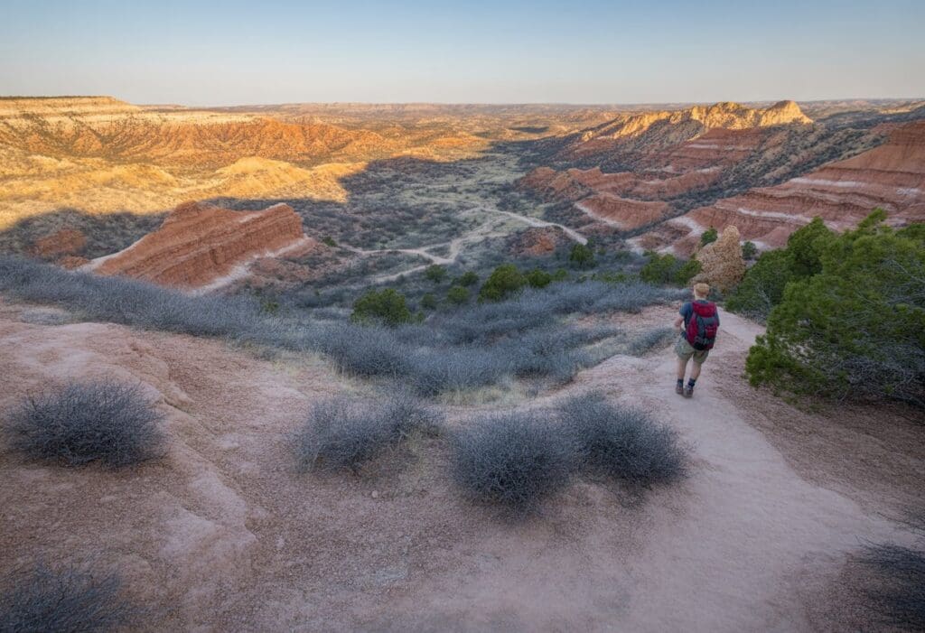
Palo Duro Canyon and Caprock Canyons State Park are where I go for big canyon views, red cliffs, and that wide-open prairie feeling.
Lighthouse Trail Highlights
The Lighthouse Trail in Palo Duro Canyon State Park is a classic. It runs about 5.7 miles round trip and leads straight to a massive hoodoo called “The Lighthouse,” which really does look like a lighthouse rising from the canyon floor.
The walk is mostly flat, but it gets rocky near the end. Shade is almost non-existent, especially in summer, so I pack extra water.
At the end, you can scramble right up to the base of the Lighthouse for the best views and photos. It’s a top spot for pictures—no question.
Quick Facts:
| Trail Name | Distance | Difficulty | Notable Feature |
|---|---|---|---|
| Lighthouse Trail | 5.7 miles | Moderate | The Lighthouse |
I like to start early to avoid the heat and the crowds.
Scenic Views in Palo Duro Canyon State Park
Palo Duro Canyon is often referred to as the “Grand Canyon of Texas” and plunges about 800 feet deep in places. Hiking here means seeing layers of colorful rock and those endless Texas skies.
The Rock Garden Trail offers a steep climb from the canyon floor to the rim, which is rewarded with panoramic overlooks. I’ve spotted Texas horned lizards and wild turkeys wandering through the brush.
Other trails, such as the Givens, Spicer & Lowry (GSL) Trail, wind past interesting rock formations. When evening falls, the park turns into an excellent spot for stargazing—clear skies, hardly any light pollution, and sometimes you can even spot the Milky Way.
Caprock Canyons Trailway Exploration
Caprock Canyons State Park is located approximately 1.5 hours from Palo Duro, offering rugged scenery and a diverse array of wildlife. I usually hike the Haynes Ridge Overlook Trail for those sweeping views over cliffs and deep red canyons.
The upper North Prong Spur leads to Fern Cave, where cool shade and ferns grow along damp walls. Caprock Canyons Trailway has more trails for hiking and biking, and prairie dogs are always popping out of burrows.
Sometimes, I’ll even cross paths with the Texas State Bison Herd. It’s quieter here than Palo Duro, and the night sky is perfect for stargazing.
Highlights of Caprock Canyons:
- Haynes Ridge Overlook Trail
- Upper North Prong Spur Trail
- Fern Cave
- Bison and prairie dog viewing
The trails can get rough, so I always wear sturdy shoes and bring more water than I think I’ll need.
East Texas Forests and Long-Distance Trails
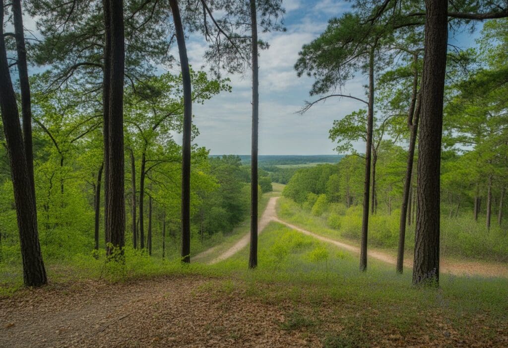
East Texas is all about dense pine forests and some of the longest hiking trails you’ll find in the state. I enjoy exploring this region for its quietness, the wildlife, and the challenge of longer hikes.
Lone Star Hiking Trail Experience
The Lone Star Hiking Trail holds the title for Texas’s longest continuous hiking trail. Depending on the route, it runs 96 to 129 miles.
The main trail and its loops cut directly through the Sam Houston National Forest, making it a truly backcountry experience. I use it for both day hikes and longer backpacking trips.
The path is mostly flat, with creek crossings and wooden bridges scattered throughout. Campsites are situated along the trail, making overnight trips easy to plan and execute.
A thick forest canopy keeps things cool, even in summer, as long as you plan. Here’s what I notice most:
- Tall pine and hardwood forests
- Quiet streams and creeks
- Boardwalks in the wet spots
- Primitive campsites for backpackers
Fall through early spring is the best window—cooler temps, fewer bugs. Trail markers are usually clear, but I always carry extra water and a paper map just to be safe.
Nature and Wildlife in Sam Houston National Forest
Sam Houston National Forest is rich in plant and animal diversity. I see pine, oak, and sweetgum trees on nearly every hike.
After a good rain, the undergrowth explodes with ferns and wildflowers. Wildlife gets busy, especially in the mornings.
I often hear the sounds of deer and squirrels, and spot woodpeckers and owls in the trees. With a bit of patience, I sometimes catch armadillos, foxes, or turtles near the creeks.
Birdwatching is solid here—warblers, hawks, and sometimes even a bald eagle during migration. I keep binoculars handy for those moments.
I stay alert for snakes in the warmer months. Most aren’t dangerous, but I stick to marked trails just in case.
Seasons change the forest in subtle ways, so every trip feels a bit different.
Additional Scenic Trails and Less-Explored Destinations
Texas hides plenty of unbeaten paths with stunning views and not many crowds. These places have dramatic landscapes, wildflowers, and unique spots that make any hike memorable.
Muleshoe Bend Recreation Area
Muleshoe Bend Recreation Area hugs the shores of Lake Travis near Spicewood, Texas. I make a point to visit in the spring, when the bluebonnets are at their best.
Trails wind through rolling hills, shady woods, and meadows dotted with wildflowers. The leading trail network spans approximately 9 miles and is open to both hikers and mountain bikers.
Most paths are easy to moderate, making them suitable for families or a leisurely walk. You’ll find clear views of the lake, with a few spots perfect for taking in the calm water.
From late March through April, wildflower photographers flock here. I appreciate that the picnic areas and campsites are well-kept.
Facilities include clean restrooms, water access, and canoe rentals.
| Feature | Details |
|---|---|
| Best Season | March–April (wildflowers) |
| Lake Access | Yes |
| Trail Length | ~9 miles total |
Seminole Canyon State Park
Seminole Canyon State Park is situated near the U.S.–Mexico border, just west of Del Rio. Deep canyons cut through the land, and desert plants thrive against the odds.
Ancient rock art is hidden along the Fate Bell Trail, which descends into the canyon and passes several pictograph sites. I once joined a guided tour; hearing stories about the region’s early inhabitants and seeing art that had survived for over 4,000 years felt surreal.
You get sweeping views of rugged cliffs and the Rio Grande, stretching out wild and open. The ground is rocky, and shade is rare, so I never forget to apply sun protection or carry extra water.
- Main trail: Fate Bell Trail (1.5 miles round-trip)
- Features: Historic rock art, scenic canyon overlooks, desert wildlife
Eagle Mountain Lake Park
Eagle Mountain Lake Park sits northwest of Fort Worth, just far enough from the city to feel like a true escape. The property spans over 400 acres, featuring more than five miles of winding, scenic trails.
Most of the paths are easy or moderate, so I don’t have to be a pro hiker to enjoy them. The trails wind through open prairies, shady woods, and up to limestone bluffs that overlook the lake.
The Good Link and Overlook Trails stand out, especially when the sun starts to drop. On a clear evening, the views across Eagle Mountain Lake are—well, you have to see them.
Birds flit through the trees, and sometimes I spot small wildlife darting along the path. It’s quiet, but not in a lonely way—more like the kind of calm that lets you hear yourself think.
Benches and rest spots appear along the way, allowing me to sit for a bit or take a photo if something catches my eye. It’s a spot that works for families, solo wanderers, or anyone who wants a peaceful hike without having to drive too far from Fort Worth.

Christian Linden is a seasoned writer and contributor at Texas View, local Texas resident, travel enthusiast.and author of the Home Energy Playbook. He specializes in topics that resonate with the Texan community. With over a decade of experience in journalism, Christian brings a wealth of knowledge in local politics, culture, and lifestyle. When he's not writing, Christian enjoys spending weekends traveling across Texas with his family, exploring everything from bustling cities to serene landscapes.