With a land area of 268,596 square miles and a population of 29.1 million, Texas is the second-largest state in the U.S. The Lone Star State had previously been an independent sovereign nation.
This distinguishes it from the neighboring states, which have never been anything other than sovereign entities of the U.S. Speaking of neighboring nations, what states border Texas?
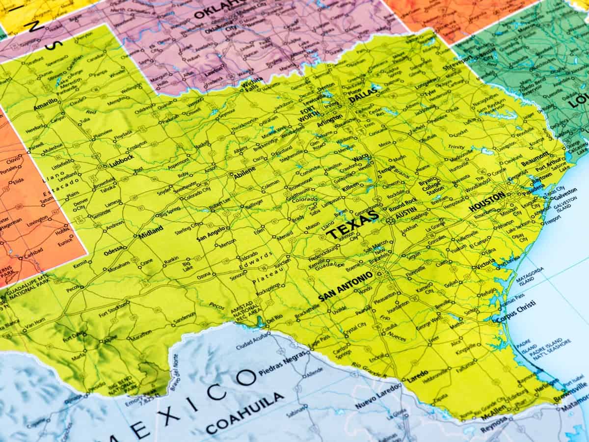
Texas shares its borders with Oklahoma on the north, Arkansas on the northeast, Louisiana on the east, and New Mexico on the west. It also borders four Mexican states: Chihuahua, Coahuila, Nuevo León, and Tamaulipas on the south and southwest.
Lastly, it has a shoreline on the Gulf of Mexico on the southeast.
A Brief History About Texas Borders
If you take a look at the History of Texas, you’ll see that the state’s borders were significantly different from what they are today. Let’s see why!
The Republic of Texas (1836-1846)
In 1836, the Republic of Texas existed as an independent country, far larger than the Texas we know today.
This is because it comprised parts of what is now Oklahoma, Colorado, Kansas, New Mexico, and Wyoming. Naturally, Texas bordered more states than it does now.
Texas Annexation (1845)
In 1845, Texas was officially admitted to the Union as the 28th state. However, it continued to have the same borders that it did as the Republic of Texas for five additional years.
Finally, the current boundaries of Texas were established following the Compromise Agreement in 1850.
States that Border Texas
Texas shares its borders with four American states: Louisiana, Arkansas, Oklahoma, and New Mexico. It also borders four Mexican States: Chihuahua, Coahuila, Nuevo León, and Tamaulipas. Additionally, it has a coastline with the Gulf of Mexico.
Louisiana
Louisiana, named after King Louis XIV, is bordered by the state of Texas on the west. Arkansas also borders it on the north, Mississippi on the east, and the Gulf of Mexico on the south.
People first stepped foot in Louisiana around 12,000 years ago. Throughout the history of this state, it was governed under ten distinct flags.
Arkansas
Arkansas, named after the Quapaw Indians, shares its borders with Texas and Oklahoma on the west and Missouri on the north. It also borders Tennessee and Mississippi on the east, and Louisiana on the south.
Arkansas formed an independent territory in 1819 and became a state in 1836. in 1861, the former slave state became the ninth state to secede from the union and join the Confederate States of America.
Oklahoma
With 3.949 million residents, Oklahoma is bordered by Texas on the south and west, Kansas on the north, and Missouri on the northeast. It also shares a border with Arkansas on the east, New Mexico on the west, and Colorado on the northwest.
In 1907, Oklahoma became the 46th state in the union. It then developed into a center for oil production, with that sector contributing significantly to the state’s early growth.
New Mexico
New Mexico is bordered to the north by Colorado, to the east by Oklahoma and Texas, to the south by Mexico, and to the west by Arizona. Its northwest corner borders Arizona, Utah, and Colorado.
Fun fact: This corner is the only place where four states meet!
In 1912, President William Taft signed the New Mexico statehood bill, establishing it as the 47th state.
Chihuahua
Chihuahua shares a border with New Mexico and Texas on the north and northeast and Coahuila on the east. Additionally, it’s bordered by Durango on the south, and the states of Sinaloa and Sonora on the west.
In 1824, Chihuahua officially became a Mexican state. It has a population of 3.742 million, which makes it the largest state in Mexico.
Coahuila
Coahuila, originally Coahuila de Zaragoza, is Mexico’s third biggest state. It’s bordered by Texas to the north and northeast, and Nuevo León to the east. Furthermore, it’s bounded by San Luis Potosi and Zacatecas to the south, and Durango and Chihuahua to the west.
Coahuila was previously merged with the state of Nuevo León. It did, however, become an independent state in 1868.
Nuevo León
Named after the New Kingdom of León, Nuevo León is the 13th largest state in Mexico. In 1824, it became a free state following the independence of Mexico.
Nuevo León is bordered by Texas to the north, both Zacatecas and San Luis Potosi to the south, Tamaulipas to the east, and Coahuila to the west.
Tamaulipas
Tamaulipas was established as a state in 1824 and was named after the Huasteca term “tamaholipa,” which means “high mountains.”
Texas borders it on the north, the Gulf of Mexico on the east, and Veracruz on the south. Also, San Luis Potos borders it on the west and southwest, and Nuevo León on the west.
The Mexican Gulf
The Mexican Gulf developed roughly 300 million years ago and covers 600,000 square miles. It borders five U.S. states, which are:
- Texas
- Louisiana
- Mississippi
- Alabama
- Florida
The Mexican Gulf also borders Cuba and part of Mexico.

What Are the Three River Boundaries of Texas?
There are three rivers that serve as natural borders for the state of Texas. They are known respectively as the Rio Grande river, the Red River, and the Sabine River.
The Rio Grande River
The Rio Grande, also known as Río Bravo del Norte or simply the Río Bravo, is the largest river in the state of Texas.
It borders southern Texas and the Mexican states of Chihuahua, Coahuila, Nuevo León, and Tamaulipas.
The Red River
The Red River is the second-largest river in the Lone Star State. It divides northern Texas from the states of Oklahoma and Arkansas.
The 1,360-mile-long Red River gets its name from its color, which results from the fact that the river carries a lot of red soil during times of flooding.
The Sabine River
The Sabine river serves as a natural border between Eastern Texas and the state of Louisiana.
It measures roughly 360 miles in length, making it the 33rd longest river in the world. It has three major branches: the Cowleech Fork, the Caddo Fork, and the South Fork.
References:
- The state of Texas used to be bigger: texasstandard.org
- 10 flags flew over Louisiana: cajungrocer.com
- Arkansas was a slave state: history.com/topics/us-states/arkansas
- The Rio Grande is the largest river in Texas: americanrivers.org

Christian Linden is a seasoned writer and contributor at Texas View, local Texas resident, travel enthusiast.and author of the Home Energy Playbook. He specializes in topics that resonate with the Texan community. With over a decade of experience in journalism, Christian brings a wealth of knowledge in local politics, culture, and lifestyle. When he's not writing, Christian enjoys spending weekends traveling across Texas with his family, exploring everything from bustling cities to serene landscapes.